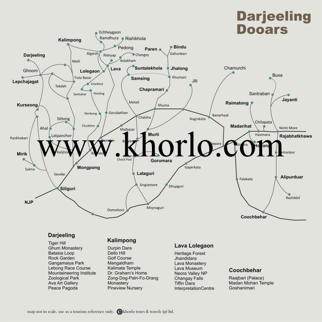
This is a Tourist Map of Darjeeling Adjoining Hill Areas & Dooars Belt
Reservation: Khorlo Tours & Travels (Private) Ltd
We are officially approved by Ministry of Tourism, Government of India. We are Registered with Department of Tourism, Government of West Bengal. Also we are a Authorised Marketing Agent (AMA) of West Bengal Tourism Development Corporation – WBTDC, & Benfish-in-Tourism Lodges)
Sikkim Commerce House, 4/1 Middleton Street, Gr Flr, Kolkata 71, West Bengal.
Please check the rules of reservation & cancellation policy before booking. It is mandatory to carry any of the Identity cards (Voter Identity Card / Passport / PAN Card / Driving License / Photo ID card issued by Central / State Govt / Adhar Card). Both these will be examined at the time of check-in.
The State has the alluvial plains known as the “dooars” in the South & the mountainous Himalaya in the North. The diversed geography of Bengal is always fascinating. The Darjeeling district is known as her scenic beauty & the tea. The dence forest region of Dooars is renowned by its collection of rich flora & fauna. The alluvial plains in the South are the basin of river Damodar, also known as the “Sorrow Of Bengal”. Other main rivers are Ganga & Hoogly. The coastal fringes of Midnapore have a curios mix of large shifting sand dunes & marshes. The district 24 pargana (South) has Sundarbans, the largest delta consists of swamps, quick sand & thick, impenetrable mangrove forest belt.
The region has its beginning in the Vedic times and was known as Vanga. The Aryans settled here after the Vedic period and many principalities and kingdoms were formed. The dynasties of Palas, the Pundras, Guptas, Mauryas and the Sens ruled over the region before the Mughals took control. The strategic location led to trade with the South East Asian countries especially Cambodia, Thailand and Myanmar. Muslim influence was responsible for a rich culture and art. The ease of access brought the Portuguese, Dutch and French influence to its art and culture. The British successfully brought the modern education to Bengal and to this date, Calcutta has been considered the land of intelligentsia. No wonder that most of the Nobel Prizes for India have come from this State; Tagore, Bhabha, Mother Teresa and Amartya Sen.
The State has the alluvial plains known as the “dooars” in the South & the mountainous Himalaya in the North. The diversed geography of Bengal is always fascinating. The Darjeeling district is known as her scenic beauty & the tea. The dence forest region of Dooars is renowned by its collection of rich flora & fauna. The alluvial plains in the South are the basin of river Damodar, also known as the “Sorrow Of Bengal”. Other main rivers are Ganga & Hoogly. The coastal fringes of Midnapore have a curios mix of large shifting sand dunes & marshes. The district 24 pargana (South) has Sundarbans, the largest delta consists of swamps, quick sand & thick, impenetrable mangrove forest belt.
The history of Bengal is intertwined with the history of the broader Indian subcontinent and the surrounding regions of South Asia and Southeast Asia. It includes modern-day Bangladesh and the Indian states of West Bengal, Tripura and Assam’s Karimganj district, located in the eastern part of the Indian subcontinent, at the apex of the Bay of Bengal and dominated by the fertile Ganges delta. The advancement of civilisation in Bengal dates back four millennia. The region was known to the ancient Greeks and Romans as Gangaridai, a powerful kingdom whose elephant forces led the withdrawal of Alexander the Great from Eastern India. The Ganges and the Brahmaputra rivers act as a geographic marker of the region, but also connects the region to the broader Indian subcontinent. Bengal, at times, has played an important role in the history of the Indian subcontinent. – WIKI
The area’s early history featured a succession of Indian empires, internal squabbling, and a tussle between Hinduism and Buddhism for dominance. Ancient Bengal was the site of several major Janapadas (kingdoms), while the earliest cities date back to the Vedic period. A thalassocracy and an entrepôt of the historic Silk Road, Ancient Bengal established colonies on Indian Ocean islands and in Southeast Asia; had strong trade links with Persia, Arabia and the Mediterranean that focused on its lucrative cotton muslin textiles. The region was part of several ancient pan-Indian empires, including the Mauryans and Guptas. It was also a bastion of regional kingdoms. The citadel of Gauda served as capital of the Gauda Kingdom, the Buddhist Pala Empire (eighth to 11th century) and Hindu Sena Empire (11th–12th century). This era saw the development of Bengali language, script, literature, music, art and architecture
Reservation: Khorlo Tours & Travels (Private) Ltd
We are officially approved by Ministry of Tourism, Government of India. We are Registered with Department of Tourism, Government of West Bengal. Also we are a Authorised Marketing Agent (AMA) of West Bengal Tourism Development Corporation – WBTDC, & Benfish-in-Tourism Lodges)
Sikkim Commerce House, 4/1 Middleton Street, Gr Flr, Kolkata 71, West Bengal.
Please check the rules of reservation & cancellation policy before booking. It is mandatory to carry any of the Identity cards (Voter Identity Card / Passport / PAN Card / Driving License / Photo ID card issued by Central / State Govt / Adhar Card). Both these will be examined at the time of check-in.